Weekly Crop Progress and Condition Report — Oct. 1, 2024
Released by the USDA National Agricultural Statistics Service
Iowa Secretary of Agriculture Mike Naig commented on the Iowa Crop Progress and Condition Report released by the USDA National Agricultural Statistics Service. The report is released weekly April through November. Additionally, the Iowa Department of Agriculture and Land Stewardship provides a weather summary each week during this time.
“As we head into October, harvest activity will move into high gear with dry conditions expected to continue,” said Secretary Naig. “Although suitable for harvest, these warm and dry conditions, paired with low humidity and gusty winds, also produce an environment that can lead to field fires. I encourage everyone to be prepared, have a plan, and keep safety top of mind as you are in the field, on the road and around the farm.”
The weekly report is also available on the USDA’s website at nass.usda.gov.
Crop report
Iowa continued to experience hot and dry conditions this week allowing Iowa farmers 6.5 days suitable for fieldwork during the week ending Sept. 29, 2024, according to the USDA, National Agricultural Statistics Service. Field activities included harvesting both corn and soybeans.
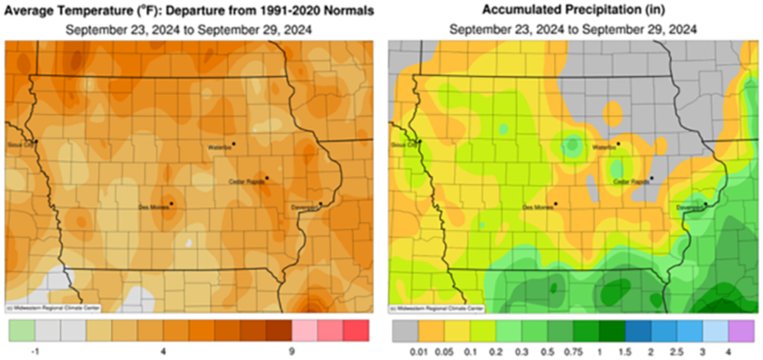
Topsoil moisture condition rated 15 percent very short, 44 percent short, 41 percent adequate and 0 percent surplus. Subsoil moisture condition rated 11 percent very short, 44 percent short, 44 percent adequate and 1 percent surplus.
Corn in the dent stage or beyond reached 97 percent this week. Corn mature reached 75 percent, 1 week behind last year but 2 days ahead of normal. Corn harvested for grain reached 11 percent, 3 days behind last year but equal to the five-year average. Corn condition remained at 77 percent good to excellent. Soybeans coloring or beyond reached 95 percent. Soybeans dropping leaves reached 80 percent, 2 days behind last year but 3 days ahead of average. Soybeans harvested reached 27 percent this week, 3 days ahead of both last year and the five-year average. Soybean condition rated 77 percent good to excellent.
Pasture condition continued to deteriorate with 44 percent rated good to excellent this week. With the continued dry conditions, some producers have had to begin hauling water to cattle.
Weather summary
Provided by Justin Glisan, Ph.D., State Climatologist, Iowa Department of Agriculture and Land Stewardship
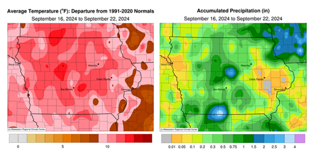
Conditions remained warmer and drier during the last reporting period of September with the highest temperature departures in northern Iowa; the statewide average temperature was 63.4 degrees, 4.7 degrees above normal. Rain was again sparce across the region with totals under 20% of normal for the week, capping off one of the driest Septembers in 152 years of statewide records.
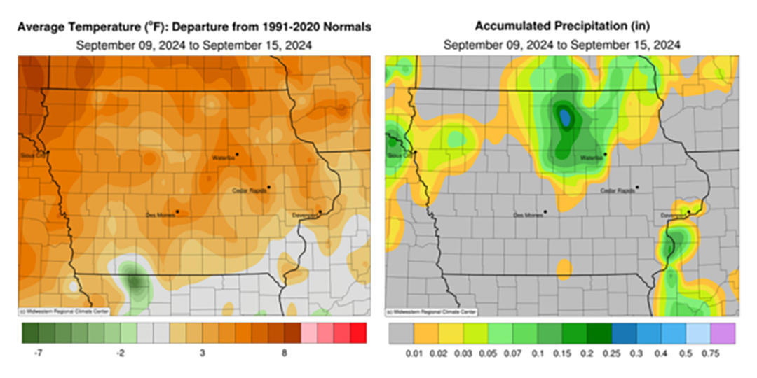
Light showers persisted into the afternoon hours of Sunday (22nd) as a cold front pushed southeast across Iowa. Northerly winds built in behind the front with clearing skies and daytime temperatures in the mid to upper 60s. Rain totals were generally under a tenth of an inch over southern Iowa though multiple stations reported higher totals; Davis City (Decatur County) registered 0.30 inch while Council Bluffs (Pottawattamie County) observed 0.56 inch. Cloudy skies redeveloped over southern Iowa into Monday (23rd) with morning lows ranging from the upper 30s northwest to low 50s southeast. Partly to mostly cloudy skies were observed in southeastern Iowa with high temperatures in the upper 60s and low 70s. Showers formed along the Iowa-Illinois border around midnight and pushed farther east as showers along a cold front moved into western Iowa close to sunrise on Tuesday (24th). The complex of showers continued east through the day as isolated thundershowers popped into the afternoon and evening hours over southern Iowa. Rain totals were highest in east-central and southeastern Iowa with more than 30 stations observing at least 0.25 inch along with multiple gauges in Lee County collecting moderate amounts; Fort Madison observed 0.32 inch with a 0.64-inch reading in Keokuk. Most of the stations that received rainfall reported an average of 0.06 inch. Afternoon conditions improved as partly cloudy skies gave way to peeks of sunshine with seasonal temperatures in the upper 60s and low 70s under light winds.
Wednesday (25th) morning began chilly across northern and western Iowa where low to mid 40s were reported. Afternoon temperatures rebounded into the upper 70s and low 80s with clouds hanging around in eastern Iowa. Clearing skies and calm to light winds into Thursday (26th) helped the surface cool back into the mid 40s to low 50s with patchy fog in southern Iowa. Daytime highs returned to the previous day’s readings with southerly to southeasterly winds. Morning lows on Friday (27th) varied from the upper 50s southeast to mid 40s northwest under cloudless skies. Afternoon temperatures, in the upper 70s to mid 80s east to west, were five to 10 degrees above normal with comfortable humidity levels. Overnight conditions into Saturday (28th) remained clear with northerly winds and temperatures from the upper 40s at several northern stations to low 60s farther south. Daytime temperatures quickly rose into the upper 80s and low 90s across the northwestern half of Iowa; the statewide average temperature was 85 degrees, 13 degrees above normal. Starry skies and light northerly winds persisted into Sunday (29th) with a broad range of temperatures varying from the upper 40s in western Iowa to the mid 50s south and east.
Weekly precipitation totals ranged from no accumulation across northeastern Iowa to 0.67 inch in Keokuk. The statewide weekly average precipitation was 0.11 inch while the normal is 0.76 inch. Little Sioux (Harrison County) reported the week’s high temperature of 91 degrees on the 28th, 18 degrees above normal. Lake Park (Dickinson County) reported the week’s low temperature of 36 degrees on the 23rd, 12 degrees below normal.