
Released by the USDA National Agricultural Statistics Service
Iowa Secretary of Agriculture Mike Naig commented on the Iowa Crop Progress and Condition Report released by the USDA National Agricultural Statistics Service. The report is released weekly April through November. Additionally, the Iowa Department of Agriculture and Land Stewardship provides a weather summary each week during this time.
“Warm, mostly dry weather kept combines rolling and helped farmers make significant harvest progress last week,” said Secretary Naig. “Iowa has experienced unseasonably warm temperatures this fall. As farmers continue fall field work, it’s important to time nutrient applications based on ’50-and-falling’ best practices instead of dates on the calendar, especially with a warmer and wetter weather pattern setting up as we head into November.”
Crop report
There were 6.4 days suitable for fieldwork during the week ending Oct. 25, 2026. Topsoil moisture condition rated 6 percent short, 81 percent adequate, and 13 percent surplus. Subsoil moisture condition rated 7 percent short, 79 percent adequate, and 14 percent surplus. Forty-seven percent of corn has been harvested, which is 20 percentage points behind the five-year average. Corn condition rated 73 percent good to excellent. Seventy-eight percent of soybeans have been harvested, which is 6 percentage points behind the five-year average. Pasture condition rated 69 percent good to excellent.
The weekly report is also available on the USDA’s website at https://esmis.nal.usda.gov/publication/crop-progress.
Weather summary
Provided by Justin Glisan, Ph.D., State Climatologist, Iowa Department of Agriculture and Land Stewardship
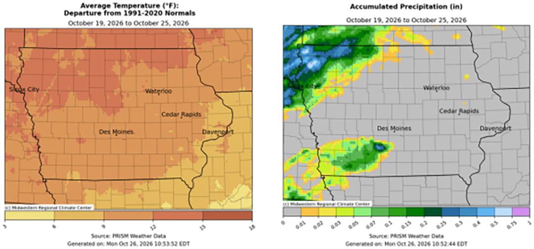
Unseasonably warm and dry conditions prevailed through the reporting period as leaves continued to change into vivid colors. Only portions of northwest and southwest Iowa observed measurable rainfall. Temperatures were well above normal over northern Iowa with positive departures nearing 15 degrees. The statewide average temperature was 59.7 degrees, 5.4 degrees above normal.
Sunday (18th) afternoon was pleasant and blustery with stronger southerly winds, sunshine and temperatures in the mid to upper 60s. Monday (19th) started off colder over northwestern Iowa where lows were in the upper 30s with slightly warmer temperatures farther south and east. Daytime highs again rose into the 60s with lighter southerly winds and a few stray clouds over southern Iowa. Winds turned easterly overnight into Tuesday (20th) with patchy fog at stations in west-central and eastern Iowa. Morning temperatures also dipped into mid 30s to low 40s. Clouds increased over southwestern Iowa later in the day as daytime highs pushed into the low 70s as southerly winds built back in. Clouds covered much of the state on Wednesday (21st) before clearing off toward the evening hours. Light showers moved into the southwest corner after midnight and continued over south-central Iowa into Thursday (22nd) before dissipating a few hours later. Rain totals were light and isolated with several stations reporting under a tenth of an inch; Creston (Union County) reported 0.13 inch while New Market (Taylor County) collected 0.18 inch. The rest of the day was nice with clear skies and temperatures in the 70s. Friday (23rd) dawned with foggy conditions across western and portions of southern Iowa. Wind speeds were light and out of the south with morning lows in the upper 40s and low 50s. Afternoon highs hit the upper 70s for most of the state as a slow moving surface boundary parked over northwest Iowa. Showers formed around midnight along the boundary while the rest of Iowa had starry skies and lows in the upper 50s southeast to low 60s southwest. Showers continued across northwest Iowa through the morning hours on Saturday (24th) as the stationary boundary shifted farther southeast. Winds were out of the north behind the boundary along with cloudy skies while the southeastern half of Iowa had southerly winds and clear skies. Rainfall totals were again not widespread with a handful of locations above 0.25 inch; Le Mars (Plymouth County) observed 0.28 inch with 0.35 inch in Sanborn (O’Brien County) and 0.62 inch in Rock Valley (Sioux County). Clouds held over northwestern Iowa into Sunday (25th) morning with lows in the upper 40s; southern Iowa remained clear with temperatures in the low to mid 50s.
Weekly precipitation totals ranged from no measurable totals at most Iowa stations to 0.43 inch in Sheldon (O’Brien County). The statewide weekly average precipitation was 0.02 inch, while the normal is 0.60 inch. Sioux City Airport (Woodbury County) reported the week’s high temperature of 81 degrees on the 22nd, 22 degrees above normal. Little Sioux (Harrison County) reported the week’s low temperature of 27 degrees on the 19th, nine degrees below normal.