Weekly Crop Progress and Condition Report — Sept. 10, 2024

From the Iowa Department of Agriculture and Land Stewardship

Iowa Secretary of Agriculture Mike Naig commented on the Iowa Crop Progress and Condition Report released by the USDA National Agricultural Statistics Service. The report is released weekly April through November. Additionally, the Iowa Department of Agriculture and Land Stewardship provides a weather summary each week during this time.

“Areas of northern Iowa received some scattered showers last week, but otherwise conditions were favorable for field and farm work,” said Secretary Naig. “Warm and dry conditions are expected for the week ahead, with better chances of rain forecasted for the second half of September.”

The weekly report is also available on the USDA’s website at nass.usda.gov.

Crop report

Iowa experienced cooler temperatures and dry conditions across most of the State. These conditions allowed Iowa farmers 6.4 days suitable for fieldwork during the week ending September 8, 2024, according to the USDA, National Agricultural Statistics Service. Field activities included cutting hay and chopping corn silage.

Topsoil moisture condition rated 3 percent very short, 29 percent short, 67 percent adequate and 1 percent surplus. Subsoil moisture condition rated 4 percent very short, 24 percent short, 70 percent adequate and 2 percent surplus.

Corn in the dough stage or beyond reached 96 percent this week. Seventy-four percent of the corn crop reached the dent stage or beyond, 6 days behind last year and 2 days behind the five-year average. Corn maturity reached 20 percent, 4 days behind last year and 1 day behind the average. Corn condition was rated 77 percent good to excellent. Soybeans setting pods reached 97 percent. Soybeans coloring or beyond reached 42 percent, 4 days behind last year and 1 day behind the five-year average. Soybeans dropping leaves reached 9 percent, 4 days behind last year and 3 days behind the five-year average. Soybean condition was 78 percent good to excellent.

The State’s third cutting of alfalfa hay reached 93 percent, 8 days behind last year but 1 week ahead of the five-year average. Pasture condition rated 63 percent good to excellent.


Weather summary

Provided by Justin Glisan, Ph.D., State Climatologist, Iowa Department of Agriculture and Land Stewardship

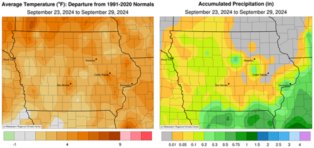
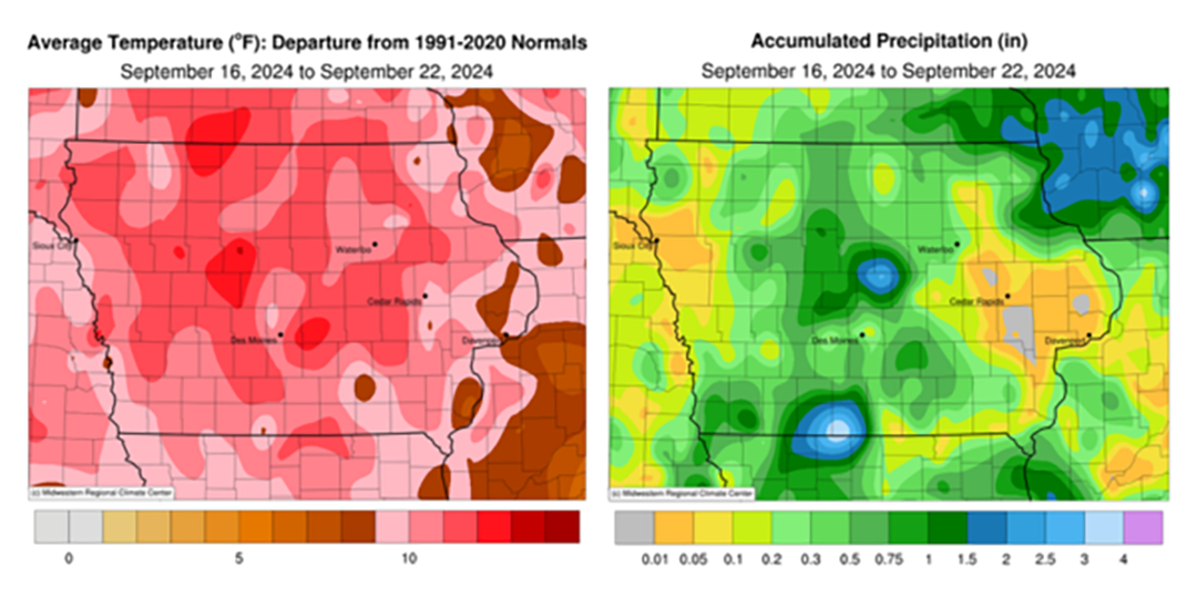
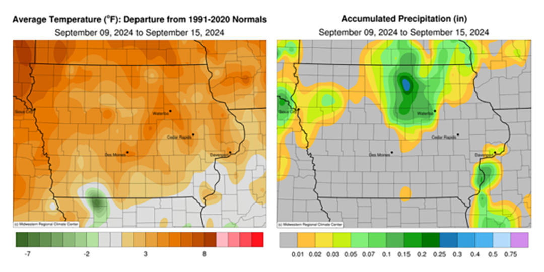
September began unseasonably cool and dry for the state with measurable but below-normal rainfall in northern Iowa; southern Iowa stations reported no measurable totals. Temperatures across eastern Iowa were up to eight degrees below normal through the reporting period with a statewide average temperature at 62.4 degrees, 6.3 degrees below normal.

Sunday (1st) afternoon was mostly sunny with northerly winds and high temperatures in the 70s. Winds became variable into Monday (2nd) morning with upper 40s and low 50s observed statewide under cloudless skies. A southerly shift in the wind helped bring temperatures back to the mid 70s with persisting clear conditions under a stable dome of high pressure. Patchy fog was observed in central Iowa around sunrise on Tuesday (3rd) with upper 40s reported in eastern Iowa; temperatures were several degrees warmer farther west where winds were more southerly. Afternoon highs rose into the upper 70s across much of the state as southerly winds increased in strength with gustier conditions in northwest Iowa. Overnight lows into Wednesday (4th) varied from the mid 50s northwest to upper 40s southeast. Daytime highs pushed into the low 80s in western Iowa in advance of a cold front moving southeast through the Upper Midwest; mid to upper 70s were observed in eastern Iowa.

Scattered showers and a few thunderstorms developed along the cold front as it entered northwest Iowa into the early morning hours of Thursday (5th). The line continued to move over northern Iowa through late morning with showers persisting in eastern Iowa after noon. Gusty northwesterly winds ushered in cooler air behind the front as clouds cleared from northwest to southeast. Event rain totals were generally under 0.10 inch where rain fell though stations in north-central Iowa registered higher amounts. Charles City (Floyd County) observed 0.39 inch while Northwood (Worth County) added an additional 0.22 inch at 7:00 am on Friday (6th) after an initial 1.12 inches was reported the previous morning. Clear skies allowed temperatures to drop in the mid 40s in western Iowa while conditions were five to 10 degrees warmer farther east. Besides some spotty showers spinning in on the backside of a low pressure center over northern Iowa, afternoon conditions were partly sunny with highs in the low to mid 70s at most stations. Several stations reported some rainfall with the highest total of 0.10 inch at Bellevue Lock and Dam (Jackson County) and Swea City (Kossuth County). Saturday (7th) started chilly with upper 30s and low 40s across eastern Iowa while stations in western Iowa registered mid to upper 40s; the statewide average low was 45 degrees, 10 degrees below normal. Afternoon conditions were ideal for the Cy-Hawk game in Iowa City (Johnson County) with highs across the state in the upper 60s and low 70s under sunshine. Temperatures into Sunday (8th) held in the mid to upper 40s for most Iowa stations.

Weekly rain totals ranged from no accumulation across Iowa’s southern two-thirds to 1.34 inches in Northwood. The statewide weekly average rainfall was 0.04 inch while the normal is 0.88 inch. Little Sioux (Harrison County) and Sioux City Airport (Woodbury County) reported the week’s high temperature of 89 degrees on the 5th, on average nine degrees above normal. Elkader (Clayton County) reported the week’s low temperature of 37 degrees on the 7th, 15 degrees below normal.

Weekly Crop Progress and Condition Report — Sept. 6, 2024

Special to the Times Vedette

Iowa Secretary of Agriculture Mike Naig commented on the Iowa Crop Progress and Condition Report released by the USDA National Agricultural Statistics Service. The report is released weekly April through November. Additionally, the Iowa Department of Agriculture and Land Stewardship provides a weather summary each week during this time.

“September is always a busy month as farmers are beginning to make harvest preparations while also seeding cover crops and chopping silage,” said Secretary Naig. “As this year’s crop heads toward maturity, the outlook for the first half of September indicates the continuation of warm and dry conditions.”

The weekly report is also available on the USDA’s website at nass.usda.gov.

Crop report

The State experienced hot conditions and scattered rain this past week. Iowa farmers averaged 5.3 days suitable for fieldwork during the week ending September 1, 2024, according to the USDA, National Agricultural Statistics Service. Activities included preparing for the fall harvest and hay cutting.

Topsoil moisture condition rated 2 percent very short, 20 percent short, 76 percent adequate and 2 percent surplus. Subsoil moisture condition rated 3 percent very short, 19 percent short, 75 percent adequate and 3 percent surplus.

Corn in the dough stage or beyond reached 94 percent this week. Sixty-one percent of the corn crop reached the dent stage, 5 days behind last year and 1 day behind the five-year average. Corn mature reached 10 percent, 2 days behind last year but 1 day ahead of the five-year average. Corn condition rated 77 percent good to excellent. Soybeans setting pods reached 95 percent. Soybeans coloring reached 18 percent, 4 days behind last year and 2 days behind the five-year average. Soybean dropping leaves began at 2 percent. Soybean condition was 77 percent good to excellent.

The State’s third cutting of alfalfa hay reached 88 percent, 1 week behind last year but 1 week ahead of the five-year average. Pasture condition rated 64 percent good to excellent.

Weather summary

Provided by Justin Glisan, Ph.D., State Climatologist, Iowa Department of Agriculture and Land Stewardship

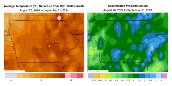
The last reporting period of August was unseasonably warm across Iowa with pockets of positive departures approaching nine degrees; the statewide average temperature was 75.7 degrees, 6.7 degrees above normal. Much of the state also experienced wetter than normal conditions with many stations collecting surplus rainfall in the 0.50- to 1.00-inch range.

Southerly winds boosted Sunday (25th) afternoon temperatures into the low to mid 90s over southern Iowa as clouds increased over northern Iowa. Overnight temperatures through Monday (26th) morning were well above normal for late August, holding in the low to mid 70s at most stations. Daytime temperatures quickly rose into the mid to upper 90s with dewpoint temperatures in the upper 70s and low 80s; the statewide average high was 95 degrees, 14 degrees above normal along with triple digit heat index values. A weak cold front dropped southeast through the state on Tuesday (27th), producing showers over northern Iowa while stronger thunderstorms fired along an outflow boundary in southeastern Iowa through the evening hours. Daytime temperatures varied from the upper 70s in northwest Iowa behind the front to the mid 90s southeast. Rainfall totals were highest over southern Iowa with nearly 30 stations collecting at least an inch of rain. Three stations in Burlington (Des Moines County) registered from 2.13 to 2.53 inches. Totals farther north and west were generally under a few tenths of an inch.

Morning lows on Wednesday (28th) varied from the upper 50s north to upper 60s south as fog and partly cloudy skies were also reported. Cloudy skies remained through the day with temperatures in the low to mid 80s under southerly winds. A small complex of thundershowers formed after midnight in northeast Iowa, leaving behind 1.55 inches at Lime Springs (Howard County) with lesser totals at a handful of stations. A strong cold front propagated across Iowa on Thursday (29th) leaving widespread totals of over one inch at more than 230 stations National Weather Service (NWS) and Community Collaborative Rain, Hail and Snow (CoCoRaHS) gauges. Eastern Iowa received the highest totals as the front slowly moved out of the state Friday (30th) morning; Marion (Linn County) registered 2.85 inches with a statewide average rainfall of 1.06 inches. Winds shifted to the northwest as cloud cover cleared southeastern Iowa by the early afternoon with daytime highs holding in the 70s. Light and variable winds developed through Saturday (31st) with morning temperatures in the 50s under clear skies. Afternoon conditions were pleasant with low 80s and southwesterly winds. Overnight lows into Sunday (1st) ranged from the mid 50s north to low 60s south.

Weekly rain totals ranged from 0.19 inch at Cherokee (Cherokee County) to 4.05 inches in Muscatine (Muscatine County). The statewide weekly average rainfall was 1.30 inches; the normal is 0.88 inch. Osceola (Clarke County) and Shenandoah (Page County) reported the week’s high temperature of 100 degrees on the 26th, on average 17 degrees above normal. Mason City Municipal Airport (Cerro Gordo County) reported the week’s low temperature of 47 degrees on the 1st, seven degrees below normal.

Weekly Crop Progress and Condition Report — Aug. 27, 2024

From the Iowa Department of Agriculture and Land Stewardship

Iowa Secretary of Agriculture Mike Naig commented on the Iowa Crop Progress and Condition Report released by the USDA National Agricultural Statistics Service. The report is released weekly April through November. Additionally, the Iowa Department of Agriculture and Land Stewardship provides a weather summary each week during this time.

“With the Farm Progress Show kicking off in central Iowa, much of the state will receive a blast of heat followed by cooler weather as we head into September,” Secretary Naig said. “This stretch of unseasonably dry conditions is providing a nice window for farmers to bale hay, chop silage and begin to seed cover crops.”

The weekly report is also available on the USDA’s website at nass.usda.gov.

Crop report

The State experienced mostly dry weather this week. These conditions allowed Iowa farmers 6.4 days suitable for fieldwork during the week ending Aug. 25, 2024, according to the USDA, National Agricultural Statistics Service. Primary field activities continued to be cutting and baling hay and preparing for the fall harvest.

Topsoil moisture condition rated 3 percent very short, 23 percent short, 72 percent adequate and 2 percent surplus. Subsoil moisture condition rated 3 percent very short, 20 percent short, 75 percent adequate and 2 percent surplus.

Corn in the dough stage or beyond reached 90 percent this week, 6 days behind last year but 1 day ahead of the five-year average. Forty-five percent of the corn crop reached the dent stage or beyond, 3 days behind last year. Corn mature reached 4 percent. Corn condition rated 77 percent good to excellent. Soybeans setting pods reached 90 percent, 9 days behind last year and 3 days behind the five-year average. Soybeans coloring reached 5 percent, 4 days behind last year and 2 days behind the average. Soybean condition was 77 percent good to excellent.  

The State’s third cutting of alfalfa hay reached 79 percent, 6 days behind last year but 6 days ahead of the five-year average. Hay condition rated 77 percent good to excellent. Pasture condition rated 65 percent good to excellent. As temperatures rose at the end of the week, stress became a concern for livestock. 

Weather summary

Provided by Justin Glisan, Ph.D., State Climatologist, Iowa Department of Agriculture and Land Stewardship

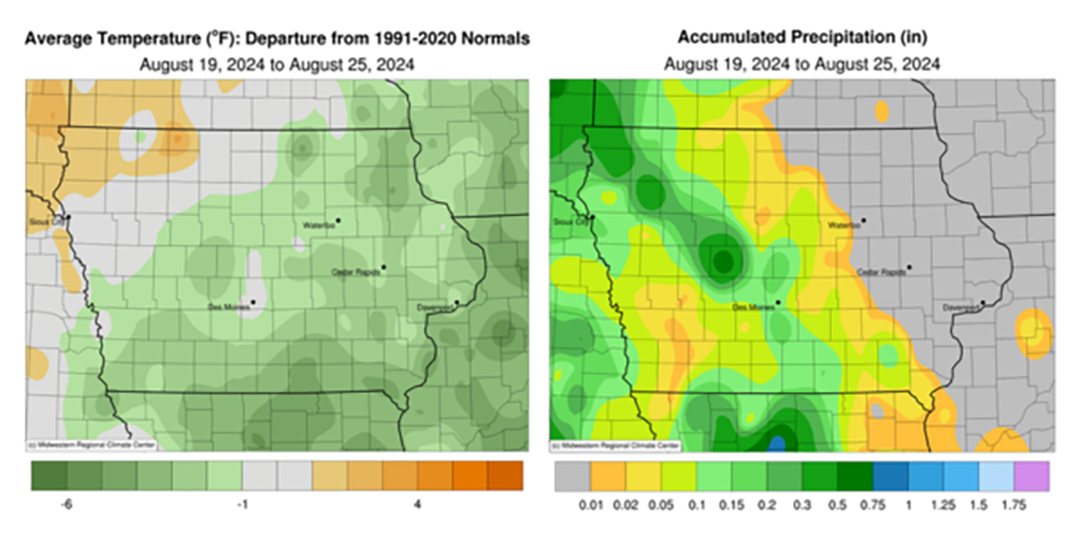
Rainfall was observed across Iowa’s western two-thirds early in the reporting period, though totals were 0.40 to 0.80 inch below normal; in eastern Iowa, deficits were over an inch in certain locations. Temperatures varied from slightly warmer across the northwest to four degrees below normal southeast; the statewide average temperature was 68.4 degrees, 3.2 degrees below normal. 

Partly cloudy skies developed over eastern Iowa through Sunday (18th) afternoon with light northerly winds and temperatures in the upper 70s and low 80s. Foggy conditions were observed overnight into Monday (19th) in the absence of strong winds and aided by clear skies for radiational cooling. The smell of Canadian wildfire smoke was also reported across the Upper Midwest from particulate mixing down into the lower atmospheric boundary layer. Northerly winds increased through the day with mid to upper 70s in eastern Iowa and low 80s farther west under sunny skies. Winds became variable after midnight as light rain showers moved along the Iowa-Nebraska border. Showers expanded over northern and central Iowa through much of Tuesday (20th) as daytime temperatures held in the 70s. Event rain totals were generally in the 0.10- to 0.25-inch range for most stations receiving rain. Pockets of southeast, central and northwest Iowa reported totals of more than 0.50 inch; Orange City (Sioux County) registered 0.51 inch while several stations in Lyon County had the highest totals, including a 0.71-inch reading at Larchwood. Mostly cloudy conditions persisted into Wednesday (21st) morning with temperatures in the upper 50s east to mid 60s west. Afternoon conditions remained partly cloudy in western Iowa while clearing occurred in eastern Iowa; afternoon temperatures remained in the low to mid 70s with southeasterly winds. A high pressure center dominating the Upper Midwest pushed farther east overnight with scattered clouds pushing into western Iowa. Thursday (22nd) morning temperatures ranged from the low 50s in eastern Iowa to low 60s west as winds shifted southerly; several eastern stations reported lows in the mid to upper 40s.

Afternoon conditions were ideal with sunny skies, light southerly winds and highs in the 70s. Overcast skies developed near daybreak on Friday (23rd) over northwest Iowa, where low temperatures stayed in the mid 60s; temperatures were five to 10 degrees cooler in eastern Iowa where clear skies and isolated fog were observed. Daytime temperatures were near-seasonal, in the upper 70s and low 80s, with mostly sunny skies. Cloud cover increased in southwestern Iowa through the nighttime hours with isolated thundershowers in west-central Iowa near sunrise on Saturday (24th). A handful of stations received measurable totals with 0.03 inch at Atlantic Municipal Airport (Cass County) and 0.41 inch in Jefferson (Greene County). Temperatures warmed into the mid to upper 80s across much of Iowa with mixed cloud cover in western and central Iowa. Overnight lows into Sunday (25th) were in the mid 60s to mid 70s with a statewide average low of 67 degrees, eight degrees above normal.

Weekly precipitation totals ranged from no accumulation across eastern Iowa to 0.93 inch at Rock Rapids (Lyon County). The statewide weekly average precipitation was 0.08 inch while the normal is 0.93 inch. Lowden (Cedar County) reported the week’s high temperature of 90 degrees on the 24th, eight degrees above normal. Elkader (Clayton County) reported the week’s low temperature of 44 degrees on the 22nd, 13 degrees below normal.

Weekly Crop Progress and Condition Report — Aug. 20, 2024

From the Iowa Department of Agriculture and Land Stewardship

Iowa Secretary of Agriculture Mike Naig commented on the Iowa Crop Progress and Condition Report released by the USDA National Agricultural Statistics Service. The report is released weekly April through November. Additionally, the Iowa Department of Agriculture and Land Stewardship provides a weather summary each week during this time.

“Overall pleasant weather helped produce record attendance at the Iowa State Fair over the last week and half, even with a few rainy days mixed in,” said Secretary Naig. “That widespread rain, coupled with the warmer temperatures forecasted through the end of August, should give crops a good boost heading into September.”

The weekly report is also available on the USDA’s website at nass.usda.gov.


Crop report

Iowa farmers averaged 4.8 days suitable for fieldwork during the week ending August 18, 2024, according to the USDA, National Agricultural Statistics Service. Field activities included cutting and baling hay and preparing for the fall harvest.

Topsoil moisture condition rated 2 percent very short, 17 percent short, 77 percent adequate and 4 percent surplus. Subsoil moisture condition rated 3 percent very short, 16 percent short, 77 percent adequate and 4 percent surplus.

Corn in the dough stage or beyond reached 82 percent this week, 3 days behind last year but 2 days ahead of the five-year average. Twenty-eight percent of the corn crop has reached the dent stage, 3 days behind last year but 1 day ahead of the five-year average. The corn crop has just begun to mature. Corn condition was rated at 77 percent good to excellent. Ninety-six percent of soybeans were blooming with 83 percent setting pods, 1 week behind last year and 3 days behind average. Soybeans have just begun turning color. Soybean condition was 77 percent good to excellent. Ninety-six percent of oats have been harvested for grain.

The State’s third cutting of alfalfa hay reached 63 percent, 1 week behind last year but 4 days ahead of the five-year average. Hay condition rated 79 percent good to excellent. Pasture condition rated 72 percent good to excellent.

Weather summary

Provided by Justin Glisan, Ph.D., State Climatologist, Iowa Department of Agriculture and Land Stewardship

Widespread rainfall was observed through the reporting period with above-normal totals in southern and western Iowa. Overall conditions were generally cool and pleasant for the Iowa State Fair. Temperatures across Iowa varied from near-normal to nearly four degrees below normal in the northwest; the statewide average temperature of 70.0 degrees, 2.2 degrees below normal.

Partly sunny skies persisted across eastern Iowa through Sunday (11th) afternoon as clouds increased farther west. Daytime temperatures held in the 70s and southerly winds developed in advance of the next weather system to impact Iowa. Showers and a few thunderstorms pushed into Iowa overnight and expanded to cover most of the state by daybreak on Monday (12th). Light showers remained in east-central Iowa through the afternoon hours as temperatures varied from the upper 60s west to upper 70s east. Most stations in the southwestern two-thirds of Iowa reported at least 0.25 inches with widespread 0.50-1.00 inch readings across swaths of central and southern Iowa; two stations in Council Bluffs (Pottawattamie County) registered 2.19 and 2.70 inches. Overcast clouds remained over most of the state into Tuesday (13th) morning with upper 50s and low 60s over northern Iowa along with widespread fog; temperatures were five to 10 degrees warmer farther south. Afternoon temperatures rose into the 70s with spotty low-80 degree readings in far eastern Iowa where skies were clear. Winds shifted to an east-southeasterly direction through the early morning hours on Wednesday (14th) as stronger storms with moderate to heavy rainfall moved into southwestern Iowa ahead of an outflow boundary. Rain continued over much of southern Iowa through late morning as a secondary complex of showers propagated over northern Iowa into the afternoon and early evening hours. A warm front associated with a low pressure center over Minnesota lifted over southwestern Iowa and acted as a focusing mechanism for additional storms into the nighttime hours. More widespread development occurred through the early hours of Thursday (15th) with showers finally moving out of eastern Iowa by noon. More than half of Iowa’s stations observed at least 0.80 inch of rainfall with nearly 155 stations hitting one inch or more. Forty stations in eastern and southern Iowa registered at least 2.00 inches; Truro (Madison County) collected 3.00 inches with and additional 3.48 inches in Council Bluffs. The statewide average for the event was 0.97 inch.

A mid-level disturbance behind the exiting system fired isolated storms, some severe warned, across southern Iowa into the evening. Heavier rainfall was reported over counties adjacent to the Mississippi River, from 0.65 inch in Keokuk (Lee County) to 1.47 inches at Bellevue Lock and Dam (Jackson County). Totals into east-central Iowa tapered off to a few tenths. Starry skies were visible at sunrise on Friday (16th) as morning lows dropped into the mid to upper 60s with a westerly wind. Increasing clouds over northern Iowa held high temperatures in the mid to upper 70s while conditions approached the upper 80s in the southwest. Scattered thundershowers developed in northeast Iowa on the backside of the low pressure feature over the Great Lakes. A handful of stations reported measurable totals with 0.21 inch in Osage (Mitchell County) to 0.85 inch in Decorah (Winneshiek County). Widespread cloud cover formed into Saturday (17th) with morning temperatures in the low 60s west to upper 60s east under northwesterly winds. Afternoon conditions were pleasant for much of Iowa with upper mid 70s to low 80s statewide and a few passing showers in eastern Iowa. Patchy fog was observed on Sunday (18th) morning with lows in the mid to upper 50s northwest.

Weekly precipitation totals ranged from 0.38 inch at Oelwein Municipal Airport (Fayette County) to 5.67 inches in Council Bluffs. The statewide weekly average precipitation was 1.33 inches while the normal is 0.93 inch. Several stations reported the week’s high temperature of 89 degrees on the 16th, on average five degrees above normal. Multiple stations reported the week’s low temperature of 48 degrees on the 12th and 18th, on average 12 degrees below normal.

Weekly Crop Progress and Condition Report — Aug. 13, 2024

From the Iowa Department of Agriculture and Land Stewardship

Iowa Secretary of Agriculture Mike Naig commented on the Iowa Crop Progress and Condition Report released by the USDA National Agricultural Statistics Service. The report is released weekly April through November. Additionally, the Iowa Department of Agriculture and Land Stewardship provides a weather summary each week during this time.

“Iowans flocked to Des Moines during the first few days of the Iowa State Fair, setting an all-time single-day attendance record on Saturday thanks to beautiful weather,” said Secretary Naig. “With favorable growing conditions expected to continue, USDA’s latest projections show record-breaking corn and soybean yield potential, all of which underscores the need to further develop new and existing markets for Iowa commodities.”

The weekly report is also available on the USDA’s website at nass.usda.gov.

Crop report

Most of the State experienced dry conditions and cool temperatures which allowed Iowa farmers 6.4 days suitable for fieldwork during the week ending August 11, 2024, according to the USDA, National Agricultural Statistics Service.  Field activities included harvesting oats for grain, cutting and baling hay, and preparing for the fall harvest.

Topsoil moisture condition rated 3 percent very short, 20 percent short, 72 percent adequate and 5 percent surplus. Subsoil moisture condition rated 3 percent very short, 16 percent short, 77 percent adequate and 4 percent surplus.

Corn silking reached 96 percent this week. Sixty-nine percent of the corn crop has reached dough stage or beyond, 1 day behind last year but 2 days ahead of the five-year average. Seventeen percent of the corn crop has reached the dent stage, 4 days behind last year but 3 days ahead of the average. Corn condition was rated 77 percent good to excellent. Ninety-four percent of soybeans were blooming, equal to the five-year average. Soybeans setting pods reached 74 percent, 5 days behind last year and 2 days behind the average. Soybean condition rated 77 percent good to excellent. Ninety-three percent of oats have been harvested, 1 day ahead of last year and 4 days ahead of average.  

The State’s second cutting of alfalfa hay reached 97 percent complete. The State’s third cutting of alfalfa hay reached 45 percent, 1 week behind last year but 2 days ahead of the five-year average. Hay condition rated 75 percent good to excellent. Pasture condition rated 63 percent good to excellent.

Weather summary

Provided by Justin Glisan, Ph.D., State Climatologist, Iowa Department of Agriculture and Land Stewardship

A stable weather pattern dominated Iowa for most of the reporting period with unseasonably cool temperatures to start the Iowa State Fair. Weekly temperature departures were in the negative three to six-degree range with a statewide average temperature of 67.0 degrees, 4.9 degrees below normal. Rainfall was limited to northern and southwestern Iowa with dry conditions in between.

Sunday (4th) afternoon was unseasonably hot with highs in the mid to upper 90s across southern Iowa while upper 80s and low 90s were observed east. Only northwestern Iowa experienced cooler conditions as a weak cold front moved southeast. Isolated thunderstorms from earlier in the day dissipated, though showers reformed across northern Iowa overnight into Monday (5th). Only a handful of stations had measurable totals ranging from 0.01 inch in Mason City (Cerro Gordo County) to 0.51 inch at Grafton (Worth County). Morning temperatures held in the 70s and rebounded into the 90s through the day as a low pressure system skirted the Iowa-Minnesota border. Cloudy conditions developed over the evening hours as showers and a few thunderstorms moved through northeastern Iowa. Gusty northwesterly winds built in as the low’s attendant cold front swept west to east, dropping Tuesday (6th) morning lows into the upper 50s to mid 60s. Rainfall was observed from north-central to northeastern Iowa with eight stations registering an inch or more; Waucoma (Fayette County) had 1.00 inch while 1.89 inches was observed in Lansing (Allamakee County). Amounts tapered off southwest with general totals under 0.20 inch. Clouds gradually cleared northwest to southeast with afternoon temperatures in the upper 60s and low 70s. Variable winds developed into Wednesday (7th) with generally clear skies and lows in the mid 50s northwest to low 60s southeast. Daytime conditions were partly cloudy as highs gradually rose into upper 70s and low 80s with high pressure in control of the Upper Midwest.

Another weak cold front dropped through the state into early Thursday (8th) with light rain showers in southwestern Iowa. Several stations reported varying amounts from 0.01 inch in Atlantic (Cass County) to 0.35 inch in Pacific (Mills County). Isolated showers also developed mid-morning in central Iowa with lighter amounts just west of the Iowa State Fairgrounds; a gauge in Urbandale (Polk County) recorded 0.03 inch from a cell that quickly diminished. Early fairgoers experienced a daytime high of 77 degrees with light northwesterly winds under sunny skies. Friday (9th) morning dawned clear with temperatures in the low 50s and some upper 40s in northwest Iowa. Upper 60s and low 70s greeted Iowans through the day as clouds increased across the state under periodic gusty northwest winds. Westerlies developed into Saturday (10th) with overnight low temperatures in the low 40s over northwestern Iowa to low 50s farther southeast; the statewide average low was 49 degrees, 13 degrees below normal. Afternoon temperatures warmed through the low to mid 70s while spotty clouds moved overhead. Stars were visible into Sunday (10th) morning with lows dropping to the upper 40s in north-central Iowa, while holding in the 50s across the rest of Iowa.

Weekly precipitation totals ranged from no accumulation for most Iowa stations to 1.95 inches in Lansing (Allamakee County). The statewide weekly average precipitation was 0.11 inch while the normal is 0.96 inch. Lamoni (Decatur County) reported the week’s high temperature of 99 degrees on the 4th, 12 degrees above normal. Mapleton (Monona County) reported the week’s low temperature of 43 degrees on the 10th, 18 degrees below normal. 

Weekly Crop Progress and Condition Report — Aug. 6, 2024

From the Iowa Department of Agriculture and Land Stewardship

Iowa Secretary of Agriculture Mike Naig commented on the Iowa Crop Progress and Condition Report released by the USDA National Agricultural Statistics Service. The report is released weekly April through November. Additionally, the Iowa Department of Agriculture and Land Stewardship provides a weather summary each week during this time.

“Before flipping the calendar into a warm first weekend of August, we finished up a particularly wet July for parts of Iowa with several rounds of thunderstorms. With the start of the Iowa State Fair this week, fairgoers can expect much more pleasant weather and temperatures. 

The weekly report is also available on the USDA’s website at nass.usda.gov.

Crop report

Most of the State received rain showers and experienced above average temperatures. These conditions allowed Iowa farmers 4.8 days suitable for fieldwork during the week ending August 4, 2024, according to the USDA, National Agricultural Statistics Service. Field activities included harvesting oats for grain, cutting and baling hay, and applying fungicides.

Topsoil moisture condition rated 1 percent very short, 12 percent short, 76 percent adequate and 11 percent surplus. Subsoil moisture condition rated 2 percent very short, 10 percent short, 79 percent adequate and 9 percent surplus.

Corn silking hit 92 percent this week, 5 days behind last year but equal to the five-year average. Fifty-one percent of the corn crop has reached dough stage or beyond, 3 days ahead of the five-year average. Eight percent of the corn crop has reached the dent state. Corn condition was rated at 77 percent good to excellent. Ninety percent of soybeans were blooming, one week behind last year but 1 day ahead of the normal. Soybeans setting pods reached 58 percent, 5 days behind last year and 3 days behind the five-year average. Soybean condition was 76 percent good to excellent. Eighty-five percent of oats have been harvested, 5 days ahead of last year and 4 days ahead of the five-year average.

The State’s second cutting of alfalfa hay reached 92 percent complete, 6 days behind last year but equal to the five-year average. The State’s third cutting of alfalfa hay reached 27 percent, 8 days behind last year but 1 day ahead of the five-year average. Hay condition rated 72 percent good to excellent. Pasture condition rated 62 percent good to excellent.

Weather summary

Provided by Justin Glisan, Ph.D., State Climatologist, Iowa Department of Agriculture and Land Stewardship

Several rounds of strong to severe thunderstorms early in the reporting period gave way to a warmer and less active pattern by the end of the week. Above-average rainfall was observed in south-central and southeastern Iowa. Temperatures were unseasonably warm with the statewide average temperature at 76.8 degrees, 3.6 degrees above normal.

Sunday (28th) afternoon temperatures quickly rose into the upper 80s and low 90s across southern Iowa as showers and thunderstorms pushed into the state’s northwest corner. The thunderstorm complex moved into central Iowa after sunset and increased in coverage across southern and eastern Iowa through early Monday (29th) morning. Many of the storms were sluggish with moderate to heavy rainfall over swaths of central and southeastern Iowa; 15 stations collected at least 2.00 inches with 3.05 inches in Fairfield (Jefferson County) to 3.51 inches in Indianola (Warren County). Most stations receiving rainfall observed at least 0.50 inch with a statewide average of 0.81 inch. Winds became variable through the day with afternoon temperatures ranging from the mid 80s north to low 90s south under mostly sunny skies. Thunderstorms entered northwestern Iowa just after midnight on Tuesday (30th) and sped southeast. As this severe-warned complex exited southeastern Iowa mid-morning, a secondary squall line followed a nearly identical path, becoming severe-warned in west-central Iowa. Locally heavy rain and several reports of strong wind gusts were reported in central to southeastern Iowa; additional discrete thunderstorms formed behind the line, producing large hail from Ankeny (Polk County) to Pella (Marion County). Stations along the axis of motion reported heavier totals above 0.75 inch with 1.00 inch in Storm Lake (Buena Vista) to 2.30 inches in Montrose (Lee County). Evening conditions were quiet as clouds cleared with a light southerly wind. Scattered overnight thunderstorms fired across central Iowa and slowly pushed southeast as a narrow line developed behind the initial convection. Storm motion was again slow with ample moisture to produce heavy rainfall; flash flood warnings were issued across several southern counties. Rainfall amounts at 7:00 am on Wednesday (31st) were high around Pella, where 5.86 inches was reported. Stations farther southeast including Oskaloosa (Mahaska County) and Ottumwa (Wapello County) registered 2.97 and 2.43-inch totals, respectively. Afternoon temperatures shot up into the mid to upper 80s as clouds moved out. Instability across southern Iowa fed a fast-moving squall line during the evening hours. The line bowed out as it moved through central Iowa, producing high winds and locally heavy rain. A secondary line pushed through northern Iowa, also producing heavy rain; Lake Mills (Winnebago County) collected 2.25 inches. The remaining days of the week were quieter and warm. Temperatures on Thursday (1st) and Friday (2nd) pushed into the 80s with partly sunny skies. Morning lows on Saturday (3rd) only fell into the mid to upper 60s with some fog observed in central to northwest Iowa. Iowans experienced upper 80s and low 90s through the day with light winds and sunny skies. Southern winds returned overnight with starry skies and Sunday (4th) morning lows in the mid to upper 60s.

Weekly precipitation totals ranged from 0.06 inch at Spencer Municipal Airport (Clay County) to 7.67 inches in Pella (Marion County). The statewide weekly average precipitation was 1.67 inches while the normal is 0.95 inch. Several stations reported the week’s high temperature of 96 degrees on multiple days, on average 11 degrees above normal. Algona (Kossuth County) reported the week’s low temperature of 51 degrees on the 2nd, 10 degrees below normal.